

Where does the grid begin, and why does it start where it does? The most common answers are: “Houston Street,” and “that’s where the city was built up to at the time.” They are partially correct answers to very different questions.
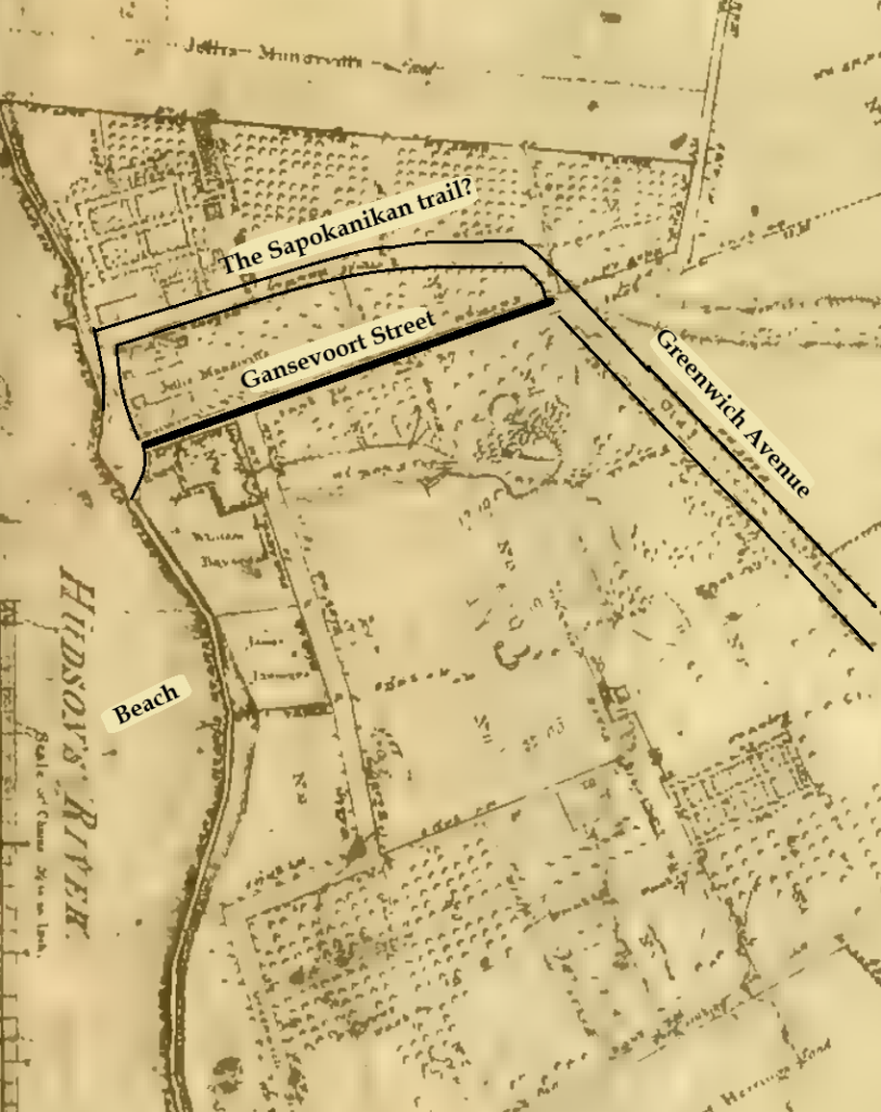
Early Native American footpaths became wagon roads in Dutch New Amsterdam, for which Broadway and the Bowery are iconic examples. Many New Yorkers are at least vaguely familiar with the idea that Astor Place, Greenwich Avenue, and Gansevoort Street have Native American origins. In fact, they were all once part of a single footpath: the Sapokanikan trail.
Greenwich Avenue was the major, half-mile-long midsection of a footpath that once connected the Hudson River to Astor Place, about a mile away. Like Broadway and the Bowery, Greenwich Avenue ossified into a wagon road and a property line over time; unlike Broadway and the Bowery, the Sapokanikan trail went crosswise to history, and it zig-zagged.
Old maps and history books (and even a cursory look) suggest the ancient Lenape footpath was incorporated “wholesale” into the grid baseline; a stunningly profound example perhaps of the Native American concept (unironically) that “the land remembers.”
The Land of the Blacks was another history that came front and center in researching this post. The Sapokanikan trail was the northern frontier of the Land of the Blacks, a large land-owning community of freed and “half-freed” slaves of the Dutch West Indie Company whose farms once stretched from Washington Square to Chinatown, and spanned 2-3 generations through Dutch and English colonial times.
It’s often told, and likely true, the city’s budget couldn’t broker the buy-outs of long-time Greenwich Village residents (or the guaranteed lawsuits to follow), and so the grid avoided the Village blocks. Today’s Greenwich Avenue is the half-mile long terminus for 10 odd-angled Village blocks; 11 if you count Gansevoort Street, which hasn’t connected with Greenwich Avenue since the 1820s (a fact very much part of the story).

image source: Google Maps (Greenwich Village ©2026 Google), with author annotation.
The grid baseline was announced in the 1807 act itself. The Commissioners were given “exclusive power to lay out streets, roads, and public squares… most conducive to public good,” and they were bound to
that part of the said city of New-York to the northward of a line commencing at the wharf of George Clinton, on Hudson River, thence running through Fitzroy-road [Gansevoort Street, trust me], Greenwich-lane [Greenwich Avenue], and Art-street [Astor Place], to the Bowery-road; thence down the Bowery-road, to North-street [Houston Street], thence through North-street in its present direction to the East River. (Stokes,1:471)
Below:
Online exhibit view of the grid baseline from: The Greatest Grid: The Master Plan of Manhattan,1811 – 2011 (courtesy of The Museum of the City of New York). Circled in red (by the author and superimposed over the museum exhibit) is an irregular, zig-zag pattern of streets between the Hudson River and the Bowery.

text transcribed from online exhibit panel above: Baseline of the Grid: In 1807 the state legislature determined that the grid would begin north of the population center. The baseline follows an irregular course, running (from east to west) across North (Houston) Street, veering north around a burial ground, before heading west on Art Street (roughly Washington Square North) and Greenwich Lane (Street). Greenwich Village and the West Village were left untouched. The first grid street to run from river to river is 14th Street. Courtesy of the Museum of the City of New York.
Sapokanikan was a natural paradise where Greenwich Village is today. Where Washington Street runs through Jane, Horatio and Gansevoort Streets was once a beach and canoe landing nestled in a sheltered cove teeming with fish, oyster beds and lobster, above which rose fields of tobacco, squash, maize, and beans. What prevented Sapokanikan from being an ideal settlement was the lack of fresh water; the Minetta River was a mile away, and downhill. It’s doubtful any large groups stayed long at Sapokanikan.
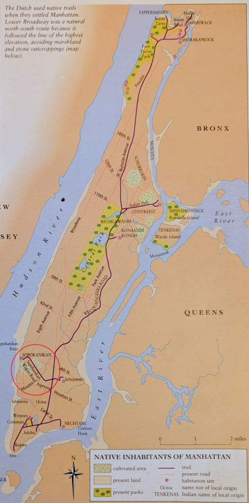
The Sapokanikan trail linked four natural features: the beach and canoe landing, acres of cultivated fields, the Minetta River, and the island’s main Wickquasgeck Path (today’s Bowery, at Astor Place). The full trail followed an S-shaped path of least resistance from the shore, through a vast clearing, and into a landscape surrounded on all sides by sandhills and wetland, on the other side of which (and running in the opposite direction) was the island’s main Wickquasgeck path, facilitating Lenape trade and travel for centuries, if not millennia.
Below:
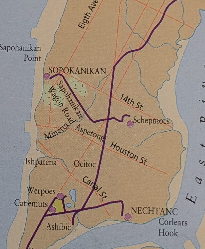
The Sapokanikan trail as illustrated in two history book standards: The Historical Atlas of New York City and Mannahatta. Notice the shapes of the Sapokanikan trail in both maps. (Left side shows full map; right zooms in)
The Historical Atlas of New York City, Eric Homberger (p.17).
Below:
Mannahatta: A Natural History of New York City, by Eric W. Sanderson (p.107).
(The text box on the page is transcribed below)
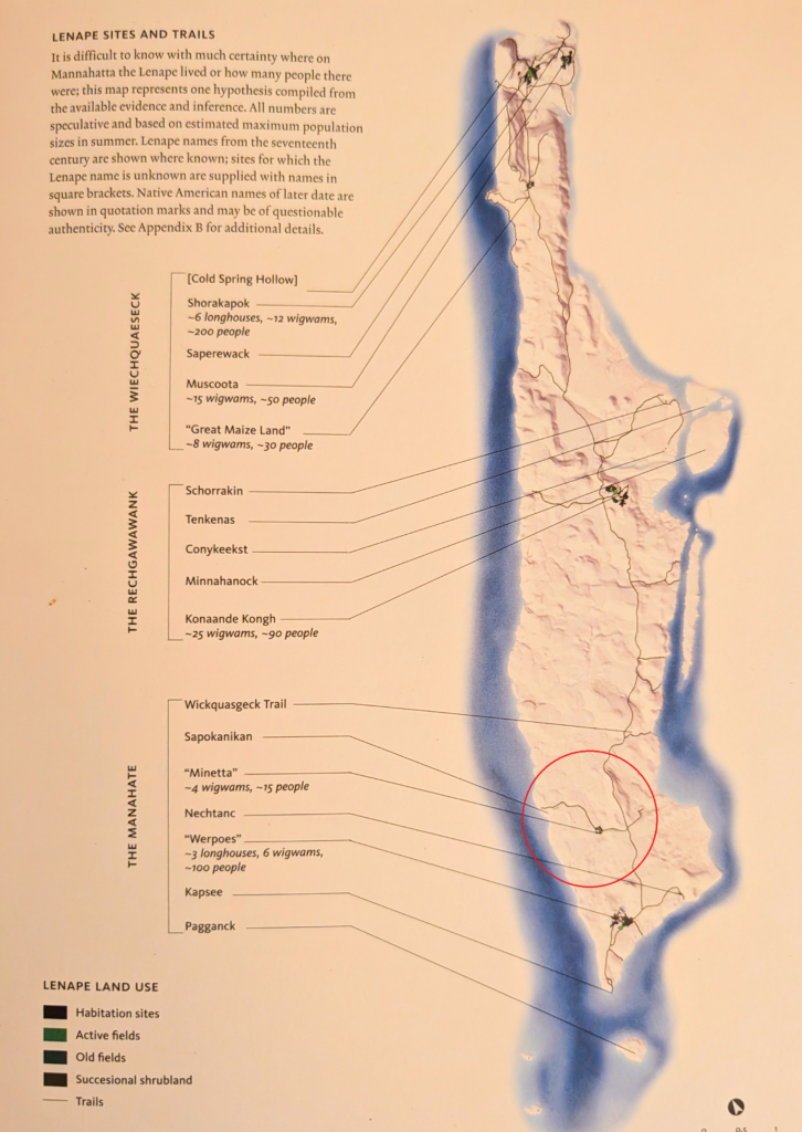
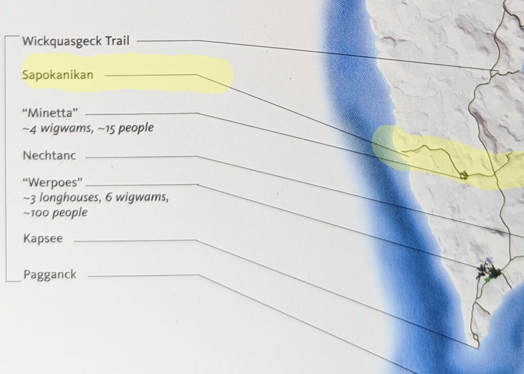
Transcribed from above: Mannahatta (p.187): Lenape Sites and Trails: It is difficult to know with much certainty where on Mannahatta the Lenape lived or how many people there were; this map represents one hypothesis compiled from the available evidence and inference. All numbers are speculative and based on estimated maximum population sizes in summer. Lenape names from the sevententh century are shown where known; sites for which the Lenape name is unknown are supplied with names in square brackets. Native American names of later date are shown in quotation marks and may be questionable authenticity.
Sapokanikan is a geographic toponym (the name derives from local geography). Sapokanikan was across the Hudson from Hoboken (which translates as “the tobacco pipe-making place” in the Munsee dialect of Algonquin tribes from Tapan and Hackensack). Sapokanikan, it’s thought, translates as “the place against the tobacco pipe-making place.”
Older history books speak of a “village” at Sapokanikan. Writing in Historic New York (1897), Elizabeth Bisland said in her essay, Old Greenwich: “On the western side of the stream [the Manetta River], broad, fertile fields stretched to the Hudson; and here, in a little, triangular space between three low hills, lay, in ancient days, the Indian village of Sappokanican.” (p.229) The “triangular space between three low hills” can be located today, but it’s generally thought small seasonal campsites was the most Sapokanikan could support.
There is plenty of evidence, however, that a footpath went through Sapokanikan, and to varying degrees segments of the path approximate three city streets today: Gansevoort Street, Greenwich Avenue and Astor Place.

image source: Google Maps (Lower Manhattan ©2026 Google), with author annotation. [Shout out to Russ & Daughters for remaining unhidden]
The baseline was once a continuous, mile-long S-shaped pattern of streets linking the Hudson River to the Bowery. And while the sigmoid curve survived the grid plan of 1811, the baseline would be a “shatter belt” of urban planning, and the “bends in the road” were shorn off in the mid-1820s. The S-shaped path became a zig-zag pattern of disconnected streets.
Circled below are the lost turns in the formerly unified path.
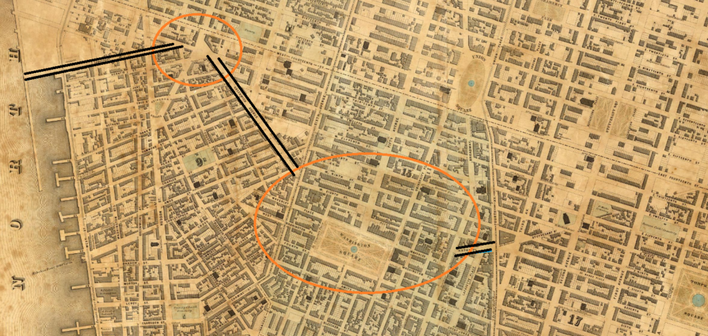
The Matthew Dripps Map of the City of New-York (1852), courtesy of the David Rumsey Map Collection, with author annotation.
Below:
The Gansevoort St.-Greenwich Ave. connection was an obtuse (wider than 90-degree) angle. It was interrupted by 13th Street and 8th Avenue in 1826.

Dripps Map detail (1852), with author annotation.
Below:
The Greenwich Ave.-Astor Place connection was almost half a mile long. As a footpath it went closer to 9th Street, as a later wagon road it dipped south two blocks to Washington Sqaure. Fifth Avenue and 8th Street overwrote the area in 1824.

Dripps Map detail (1852), with author annotation.
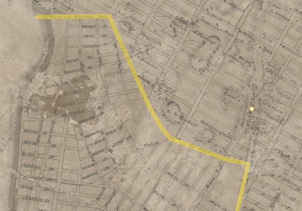
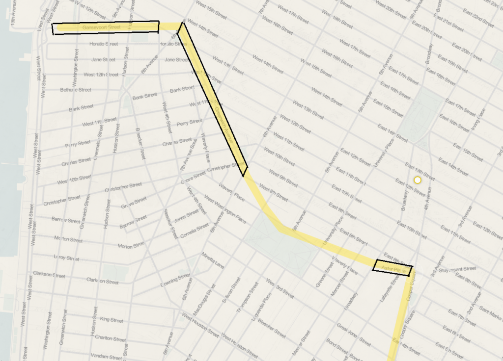
Comparative Grid Overlays
From the Museum of the CIty of New York’s “The Greatest Grid” exhibit.
(left) The grid baseline; (right) baseline on modern streets with author annotation showing: Gansevoort Street, Greenwich Avenue, and Astor Place.
Let’s look for the Sapokanikan trail in history, starting with the foundational work, Indian Paths in the Great Metropolis, by Reginald Bolton (New York: Museum of the American Indian, Heye Foundation, 1922).
In both Bolton’s book and Mannahatta, the Sapokanikan trail veers north around sandhills between the Minetta River and the Wickquasgeck Path (Bowery Road).
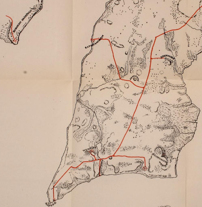
Bolton, 1922: Lower Manhattan in Aboriginal Times, p.34, facing page.
Bolton’s full commentary below on the Sapokanikan trail (all three streets are bolded, including their earlier names):
At the line of Astor Place another pathway branched westwards. This was an important connection between the main line of travel and the landing-place on the shore of the Hudson by which trade in peltries and food was conducted with the tribes on the west side of the estuary. This place was known as Sapohanikan, and was situated on the curving shore of the river at our present Gansevoort Street. The tide-line in those days was well inland of Washington Street, and the stretch of shelving shore between Bethune and Horatio streets formed a shallow cove suited to the landing of laden canoes at all heights of the tide.
There does not appear to have been any fresh-water supply at or near this place, so that it would have lacked the most important element necessary to permanent residence. It was, in point of fact, a trading station only, occupied by those who met there to exchange goods with the natives of Hobokan, a terminal to which the people of the East New Jersey mountain regions brought skins and meat, to be ferried directly across the river to Sapohanikan. The name denotes its position “over against the pipe-making place,” and thus indicates its character as a convenient spot for communication rather than for residence.
We may assume that the path from this place was a well-trodden and probably widened way on which the bearers of bundles of furs, carcasses of moose and deer, baskets of oysters, and strings of fish, passed one another on their way to and from their distant homes.
The line of this pathway was directed by the physical conditions of the tract over which it passed to a connection with the main trail at Astor Place. From the landing place it probably proceeded east over the line of Gansevoort Street to the head of Greenwich Avenue. This is the old Monument Lane of the Colonial period, which proceeds in a striaght line toward Washington Square. At this point the path crossed the rivulet known to the natives as Minetta, and to their successors as the Bestavaer brook. It turned eastward at this crossing, and cut across the present lots north of Waverly Place, passing there between two hillocks, one of which was known as the Sandberg, or Sand hill, and that on the south by a native name, which Schoolcraft gives as Ispetong, probably Aspetong, referring to an elevated Place. The line of Astor Place is doubtless the result of the junction of the two paths at this point. (Bolton, pp 58-61)
The Manatus Map, c.1639
The Sapokanikan trail is a prominent feature on one of Manhattan’s earliest maps, the Manatus Map (c.1639), depicting New Amsterdam’s “forts and mills belonging to the West India Company, the bouweries or farms of the early settlers, and all the important topological features.” (Stokes, 2:181)
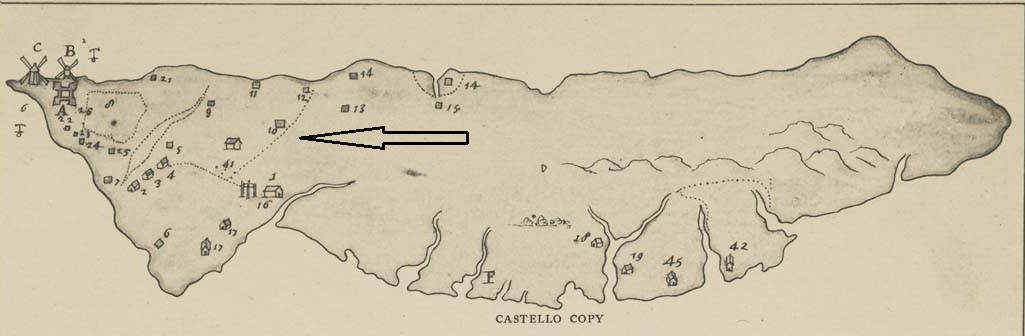
Johannes Vingbooks, Manatvus op de Noord Rivier, c. 1639, Castello copy. (reproduced in I.N. Phelps Stokes, The Iconography of Manhattan Island, vol. 2, C.plate 42a, with author’s arrow annotation).
Below is the earliest mention of the “Sapokanikan wagon road,” according to The Iconography of Manhattan Island, 1498-1909 (Stokes, I.N. Phelps: Robert H. Dodd, 1915-1928), going forward referred to as “Stokes“:
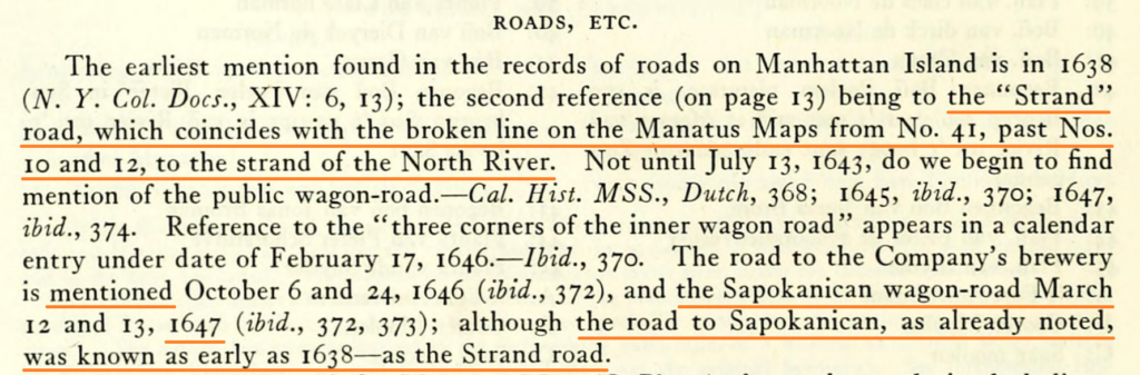
Stokes, 2:186, underlined by author.
Below:
The Sapokanikan trail was a property line as early as 1639. According to Stokes, “[Plantation nos. 9], 10, 11, and 12 were bounded easterly and northerly by the road of which our present Greenwich Avenue forms a part, and which curved out to the river above Gansevoort Street. They were bounded south probably by the Manetta water to its outlet near Charlton Street.”(Stokes, 2:190)
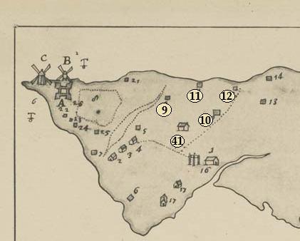
Detail of Manatus Map, 1639, with author annotation.
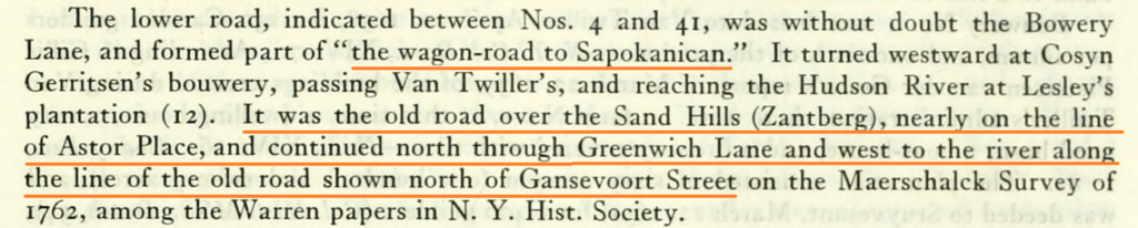
Stokes aligns today’s streets with the Sapokanikan wagon-road, giving us a Rosetta Stone-like clue aligning the wagon road with the footpath:
Stokes, 2:187, underlined by author
The wagon-road to Sapokanikan went nearly on the line with Astor Place… through Greenwich Avenue… and north of Gansevoort Street.
Like many downtown streets, Gansevoort, Greenwich and Astor had many names through history. More confusing still, since they were all once part of the same continuous path, their identities often merged. Here (I think) is a complete list of their names, in rough order of use:
Gansevoort Street:
Old Kill road
Old Kiln road
sometimes as an extension of…
Greenwich Lane
Fitzroy road
South Hampton road
Greenwich Avenue:
Old Highway/Indian Road
wagon road to Sapokanikan
Gerritson’s wagon-road
Road to Greenwich
Monument Lane
Road to the Obelisk
Greenwich Lane
Astor Place:
Zantberg
Sand Hills Road
Art Street
sometimes as an extension of any of Greenwich Avenue’s identites.
Let’s look at them across time in Stokes’ commentaries, narratives and grant and farm documents.
Stokes, Manatus Map, c.1639, with author annotation.
The landmarks above:
#41 Cosyn Gerritsen van Putten (a master wheelwright) was granted about 70 acres in 1647, “This plantation was bounded east by the wagon-road from Sapokanikan (the Bowery Lane as far as the point where the road over the Sand Hills met it, was often so called)…It covered land lying south of the road over the Sand Hills, corresponding with the present Astor Place, and is correctly placed on the Manatus Map.” (Stokes, 2:203)
#10 Wouter Van Twiller was the fifth Director of New Amsterdam (1633-38), a despicable leader all around he forced the Lenape off their tobacco fields in “lower Sapokanikan” in the late 1620s. His homestead (#10) was a ten-acre parcel, the Bosson Bouwerie (farm in the woods), and was on “a hilly tract of land east of the old Indian road to Sapokanikan, with a fresh meadow behind it, was surrounded on the south and east sides by Manette Creek….Van Twiller retained the homestead until his death. It was the last remnant of his large bouwery.” (Stokes:6:162).
In 1638, the even more despicable and incompetent Director Kieft granted the corrupt van Twiller an official patent for more than 200 acres of land “near Sapokanikan on the North river with palisades around it” (Stokes 2:190). The land came with the caveat that “all such roads and foot-paths as already run through this land shall continue there for the use of the inhabitants.” (Stokes 2:191). Regarding this early act of preservation, Stokes says:
This reservation of existing roads for the use of the inhabitants is the earliest noted in the land records of Manhattan. The old Bowery Road and the road along the north line of Bouwery 12, called ‘Cosyn Gerritsen’s wagon road,’ or ‘the old Highway,’ date from 1625, at least…. The old road to Greenwich, which extended northward along the line of the later Fitzroy road to the Great Kills, was an early Indian trail.” Stokes (6:164) [Note: the Great Kills mentioned here was not Old Kill Road, an early name for Gansevoort Street; the Great Kills Road was around 42nd Street].
Director Kieft’s near decade-long rule of New Amsterdam was disastrous, culminating in the so-called “Kieft’s War” 1643-1645 with the Lenape. Whether it was paranoia, greed, revenge or all three, Keift was intent on attacking refugees from an inter-tribal war encamped at Communipaw (NJ) and Corlear’s Hook on a February night in 1643, slaughtering 120 Lenape men, women and children. The two-years long counterattack by the united Lenape and their allies across the region laid waste to New Amsterdam’s outlying settlements (Anne Hutchinson’s community is recalled in the Hutchinson River Parkway).
from 500, the population of New Amsterdam dropped by half, and the colony was reduced to a fighting force of 100.
New Amsterdam’s first slaves are considered the “Charter Generation” by author and historian Ira Berlin. Eleven men and three women arrived in 1626 as property of the Dutch West Indie Company. Over the next 20 years their numbers increased by only a few dozen; slavery would not be major commodity in the port of New Amsterdam until after Peter Stuyvesant’s arrival in 1647.
The Charter Generation were largely Atlantic Rim Creoles from Angola, Congo and San Tome. From the colonies, they were often raised in the seafaring trades and captured from Spanish and Portuguese ships. Many were multi-lingual with names that often reflected a geographic origin, occupation, or physical attribute, like Anthony Portuguese, Simon Congo, Manuel Trumpeter, Cleijn Anthony (Little Anthony), Manuel the Spaniard, and Big Manuel. They cleared the land, built the forts, farms, roads, and mills, cut and processed timber, operated mills, and processed wheat, corn, oats and barley for export, among other things.
In the Dutch system, slavery was not outwardly racial or codified. In early New Amsterdam slaves could hire out their own labor and sue if they weren’t paid. In 1635, five black men working for the Dutch West Indie company sued and won an increase in wages.
At the height of Keift’s War in February, 1644, eleven members of the Charter Generation sued for their freedom. Leveraging their position for sure, they argued they needed to take care of their own families, and each had given almost 20 years of service to the company and the colony. Keift granted them and their wives half-freedoms, cruelly claiming their children as company property.
According to Stokes, “The negro lots along the west side of the Bowery Road, between Prince St. (the old Indian trench or graft) and Astor Place (the old highway, or Cosyn Gerritsen’s wagon way), were taken from Wouter van Twiller’s plantation when it reverted to the Dutch Government….These were all Stuyvesant ground-briefs, but the negroes had been there for a long time before the patents were issued” (Stokes, 6:123). Stokes often notes the Charter Generation had been living on their lands before they were officially granted.
It was a tactical move by Kieft to create a buffer zone in the wake of his catastrophic war.
Manuel Trumpeter was not among the eleven petitioners, but as Captain of the Blacks and leader of the slave militia, he was granted 18 acres overlapping today’s Washington Square Park. Trumpeter’s farm was among the first, and the northernmost, of the eventual dozens of farms that came to comprise The Land of the Blacks.
The Sapokanikan trail was within feet of Manuel Trumpeter’s “front door.” Kieft’s ground-brief to Trumpeter was “a certain piece of land stretching on the east side of Anthony Portugueses to Cossin [Cosyn] Gerrits Waggon-path.” (Stokes, 6:105). Christopher Moore says in A World of Possibilities: Slavery and Freedom in Dutch New Amsterdam, Trumpeter’s land was a “cut-off point for the Indian attacks at what is now Fifth Avenue and Washington Square North.”
While the colonists’ buffer zone expanded, a semi-autonomous, close knit community of families stretched from Washington Square Park to Prince Street, and from the Bowery to Tribeca.
In Slavery in New York (The New Press, 2005), Chirstopher Moore says:
By mid-century, free black farmsteads spread over 130 acres–100 square city blocks–of Manhattan. Commonly, the farms were thatched- or wooden-roof homes with some cattle, goats, and sheep, and a garden. The black-owned farms ranged in size from eight to twelve acres. The “negroes land” or “land of the blacks”–legal terms used in later conveyances and descriptions of the property–was located about a mile north of New Amsterdam, extending northward along the hilly and swamp-ridden region of Manhattan’s rugged central wildernerness. On this forbidding land emerged the first legally (emphasis added) emancipated community of people of African descent in North American. [Moore notes the legal standing of the Charter Generation distinguishes it from earlier black communities in Florida and Mexico.]
Below:
The Stokes Landmarks Map showing Original Grants and Farms. Circled in yellow are the names of some of the dozens of farms with their grant dates, including: Manuel Trompeter (12/12/43), Anthony Portuguese (12/5/45), Manuel Gerrit De Reus (orig brief lost; reconfirmed by Governor Nicolls, 9/14/68), Groot Manuel (Big Manuel, 12/21/44), Paulo Angelo (7/14/45), Cleyn Manuel (Little Manuel), Peter Santome (12/15/44), Symon Congo (12/15/44), Cleyn Antonio (Little Anthony, 12/30/44) Gratia D’Angelo (12/15/44), Peter Santemeo (12/15/44), and Big Manuel (10/19/45).

(Stokes, 6: PL.84B-b: Original Grants and Farms, with author annotation.
The community’s landholdings would be re-confirmed by Governor Nicolls after the English took over in 1664, and the Land of the Blacks continued until the 1710s; 70 years, almost twice as long as New Amsterdam.
In the Journal of Jasper Dankaert, the missionary wrote of the neighborhood in 1679:
We went from the city, following the Broadway, over the valley, or the fresh water. Upon both sides of this way were many habitations of negroes, mulattoes and whites. These negroes were formerly the proper slaves of the (West India) company, but, in consequence of the frequent changes and conquests of the country, they have obtained their freedom and settled themselves down where they have thought proper, and thus on this road, where they have ground enough to live on with their families. Journal of Jasper Dankaerts (Charles Scribner’s Sons, 1913, p.65)
Surrounding property owners like the Stuyvesants and Bayards harassed the community in the courts, but the Land of the Blacks continued for 2-3 generations, until the backlash following the Slave Revolt of 1712.
An official slave market opened at the foot of Wall Street on December 3, 1711. On April 6, 1712 dozens of slaves set fire to an outbuilding near Maiden Lane and ambushed respondents, killing and wounding more than a dozen colonists. 70 slaves were arrested and others were subject to varous public tortures and executions; an inhuman, gruesome generational trauma that facilitated the institution’s continuity until the next generational trauma and the “Slave Conspiracy of 1741,” thirty years later.
Among other restrictions after the Slave Revolt of 1712, slaves could only gather in limited numbers. One insidious law prevented blacks from inheriting property. With that, the families of the Charter Generation sold off their lands by 1716 and moved away, many followed in the path of the Dutch Reform Church into the river valleys of New Jersey.
The Charter Generation started the Land of the Blacks in a colony with a population of 200-300 in the 1640s, 70 years later, the largely Dutch-speaking community had seen the population grow around them to more than 6,000 (5,000 English and 1000-1500 African slaves).
The general boundaries of The Land of the Blacks were: The Sapokanikan Trail, the Wicksquasgeck Path, Prince Street, Lispenard’s Meadow and the Minetta River.

The palimpsest extends beyond the built environment. A hill shared by Symon Congo and Cleyn Antonio (who may have used it for rough grazing or, as Abigail Adams suggested below, contemplation) eventually became part of Trinity Church’s King’s Farm holdings. In 1767 Abraham Mortier, Deputy Paymaster-General of the British Army, built a Palladian home on the hilltop, Richmond Hill. It was used by George Washington (in war), John Adams (as Vice-President), and Aaron Burr (who lived in it for more than a decade). Abigail Adams wrote about living there 1789 as the first Second Lady. It’s where Charlton, Vandam and MacDougal Street are today (the hill was leveled in the 1830s).
The house in which we reside is situated on a hill, the avenue to which is interspersed with forest trees, under which a shrubbery rather too luxuriant and wild has taken shelter… In front of the house, the noble Hudson rolls his majestic waves, bearing upon his bosom innumerable small vessels. On the right hand [towards Sapokanikan], an extensive plain presents us with a view of fields covered with verdure, and pastures full of cattle. On the left, the city opens upon us, intercepted only by clumps of trees and some rising ground which serves to heighten the beauty of the scene by appearing to conceal a part. In the background is a large flower garden, enclosed with a hedge and some very handsome trees. On one side of it, a grove of pines and oaks fit for contemplation…. A lovely variety of birds serenade me morning and evening, rejoicing in their liberty and security, for I have as much as possible prohibited the grounds from invasion. The partridge, the woodcock, and the pigeon are too great temptations to the sportsmen to withstand…In natural beauty it might vie with the most delicious spot I ever saw. (This Was New York: The Nation’s Capital in 1789; Doubleday, 1943, p.43)
From where it began at “the foot of Gansevoort Street,” the Sapokanikan trail went northeasterly around some hillsides before turning to follow today’s Greenwich Avenue downhill on a mile-long track to the Minetta River, passing farms and fields of tobacco, corn and maize. Approaching the river, the ground leveled out and the scene became more wooded as the trail entered the environs of the river around today’s Washington Square Park. Here the path lost its integrity navigating lush undergrowth in a more vital landscape, it was supposed to be the location of an early Sailor’s Snug Harbor. The river ran slower here, and water may have been easier to collect. After diverting around some sandhills, the Sapokanikan trail ended where it connected with the Island’s main path at Astor Place, the Wickquasgeck trail (Lenape from the Bronx and Westchester).
Let’s look at the full Sapokanikan trail, starting with Gansevoort Street and the Viele Map.
The Viele Map
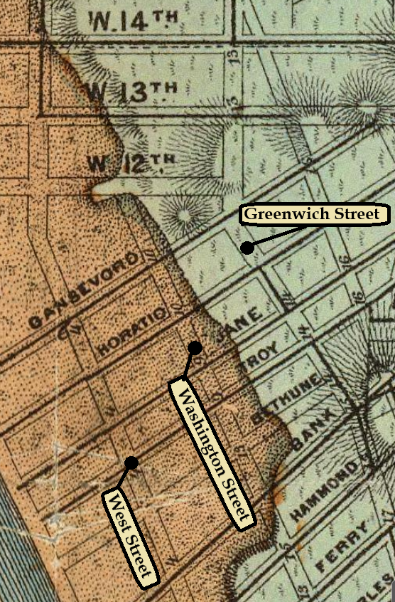
Detail of Viele Map, 1865, showing Sapokanikan beach, with author annotation.
In the seventeenth century, before two blocks of landfill stretching from Greenwich to West Streets were added to the Hudson River shore, today’s Greenwich Street followed the river’s shoreline. Here, between today’s Bethune Street and Horatio Stret three blocks to the north, was a sheltered cove called Sapokanikan. This was a landing place and probably a trading spot for the Hackensack Indian groups who came to Manhattan to trade. Some of the traders may have come from the interior of New Jersey, crossing the Hudson, which was called Mahikanituk, from today’s Hoboken, which was also a trading place at that time. Some think that a trail led from this landing place over to Gansevoort Street and then along the line of today’s Greenwich Avenue toward today’s Washington Square. (Touring Gotham’s Archaeological Past; Yale University Press; 2004, p.59)
Today, the shoreline promontory is a protuberance in West Street after centuries of landfill (circled below). The commanding view of the Hudson River and Jersey from Sapokanikan Point is now the site of the Whitney Museum (a bit off shore). The canoe landing at Greenwich Street is marked below.
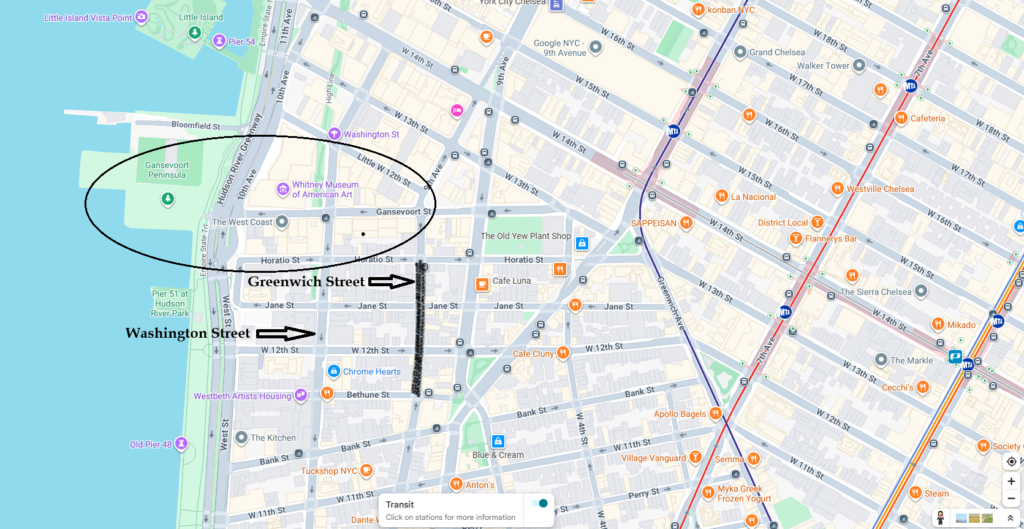
image source: Google Maps (West Village ©2026 Google), with author annotation.
Gansevoort Street was named in 1837, after a fort built at the end of it for the War of 1812 (and named for Revolutionary War General Peter Gansevoort). Over time, the fort was replaced with railyards, and then for decades produce and meat markets thrived at the ever-extending “foot of Gansevoort Street.”
In the history books “the foot of Gansevoort” has always been a mosaic that defies linear narrative. A short, out-of-the-way, alley-like block with a highly specific place-qualifier; it’s both the start of the Sapokanikan trail and the grid baseline? 150 years, and a block-and-a-half of landfill apart? It’s quite a coincidence for so specific a coordinate.
Not to be cinematic, but the “foot” of Gansevoort Street was a portal of intermodal transit, a liminal space (right, in red) that passed up from the beach and canoe landing to dry, high ground and cultivated fields. Probably with an easy grade, the gap in the waterfront was a “commercial” ramp (and start of the trail) for Lenape trade and travel. At the north end of the cove, it went between the promontory (Sapokanikan Point) and a hill (Wm. Bayard lived at the top, we’ll see).
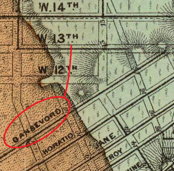
Detail of Viele Map, 1865, showing the West Village, with author annotation.
Below:
Two arrows point to the foot of Gansevoort Street (where the trail starts), and where it needed to connect at Greenwich Avenue. The straight line follows Gansevoort Street, and was not the route of the Sapokanikan footpath. Oliver Delancey built Gansevoort Street around 1762, it was first known as Old Kill Road. The other path in red arcs north, almost to 14th Street, and was a more likely, grade-level footpath around the hills of the estuarine woodland. Gansevoort Street “short-circuited” (bypassed) the footpath’s more circuitous route to the water. Recall Stokes said the wagon road went “north of” Gansevoort Street. But let’s keep looking.
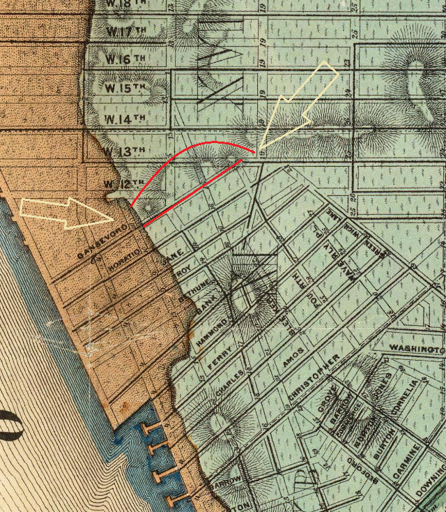
Detail of Viele Map, 1865, showing Gansevoort Street, with author annotation.
The Ratzer Map, 1766-67
Following the Stamp Act Riots of 1765, British officers created detailed maps of the city. The Ratzer Plan (1766-67) shows the natural environment along with roads and farm boundaries. The next maps zoom in on the Sapokanikan trail.
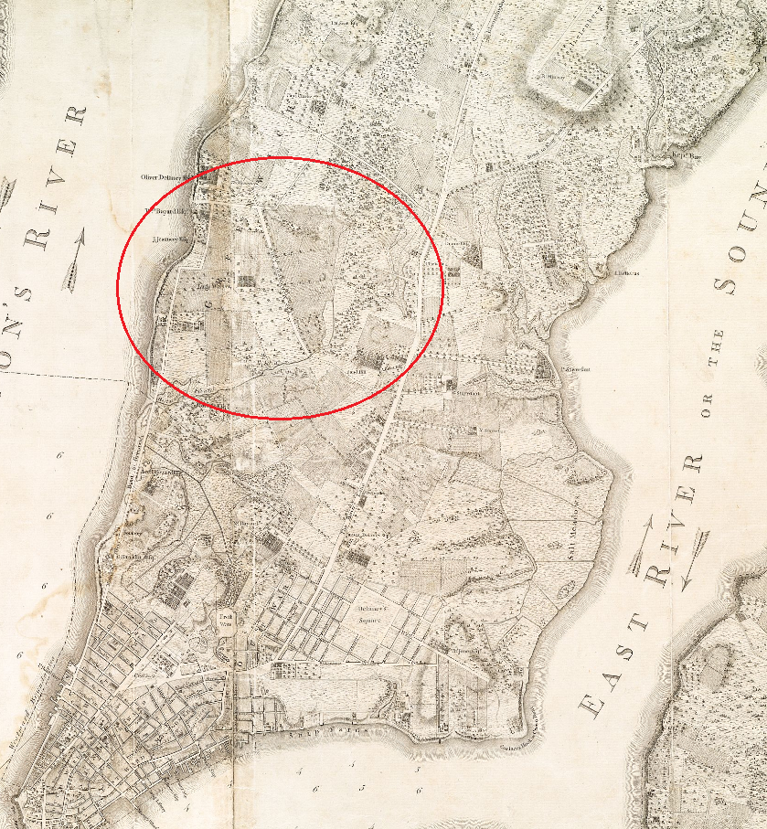
Plan of the city of New York in North America: surveyed in the years 1766 & 1767 (Bernard Ratzer), Courtesy of the Lionel Pincus and Princess Firyal Map Division, NYPL, with author annotation.
Notice the names in the upper left on the map: DeLancey, Bayard, and Jeauncey. The next map will include “Mandeville,” just below DeLancey.
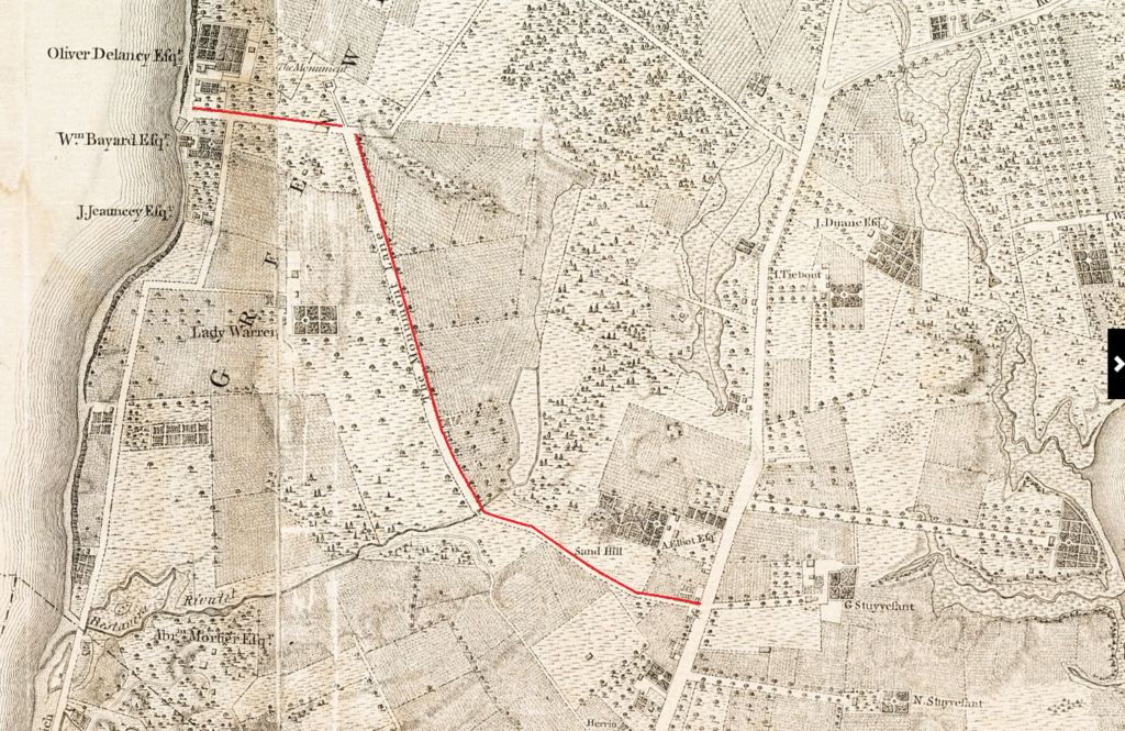
Detail of the Ratzer Map, 1766, showing Sapokanikan wagon road, with author annotation.
Greenwich Village was named by Yellis Mandeville in the 1690s, a Dutch colonist from Brooklyn, when the Land of the Blacks was at the other end of the Sapokanikan trail. In the 1670s, Mandeville received a patent for 126 acres stretching from around Gansevoort Street to today’s Chelsea.
By the time the Ratzer Map was made almost 100 years later, the Land of the Blacks had disbanded, and the Mandeville estate had been sold off largely to Peter Warren (a successful Vice-Admiral and Naval Commander in an era or war and plunder), and reduced to a relatively small, 8-acre parcel on which David Mandeville, Yellis Mandeville’s grandson, resided. The surviving Mandeville plot included the family homestead, the family cemetery, and what history would record as “the foot of Gansevoort Street.”
Below:
Note: “passage” and “Mandeville.”
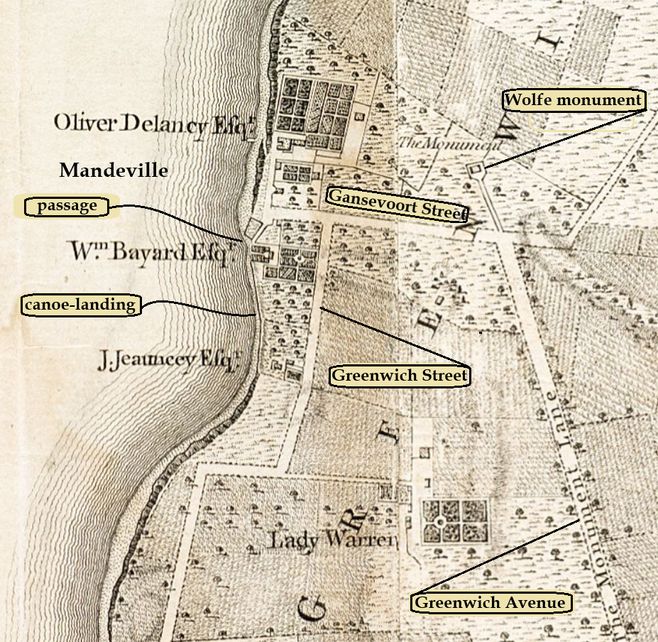
Detail of the Ratzer Map, 1766, showing Greenwich Village, with author annotation.
Writing In Old New York in the 1890s, Thomas Janvier says:
For more than a century and a quarter the Warren house was the most important dwelling on this portion of the island. It was the nucleus about which other country-seats clustered–including, before the year 1767, those of William Bayard, James Jauncey, and Oliver DeLancey, Lady Warren’s brother; whose earlier estate was confiscated because of his loyalty to the crown. (Thomas A. Janvier, In Old New York, 1894, p. 117)
Peter Warren, Lady Warren, and their three daughters moved to London in 1747 (Peter Warren died in 1753 and is buried in Westminster Abbey). Lady Warren’s brother, Oliver DeLancey, was overseeing things in New York when the Ratzer Map was made in 1766.
Below:
The Viele Map shows the homes on the Ratzer Map in the local topography. The Bayard and Jauncey homes fronted the beach and canoe landing, spanning today’s Horatio and Bethune Streets. A red arrow points to where the passage led up between the DeLancey and Mandeville properties…the foot of Gansevoort Street.
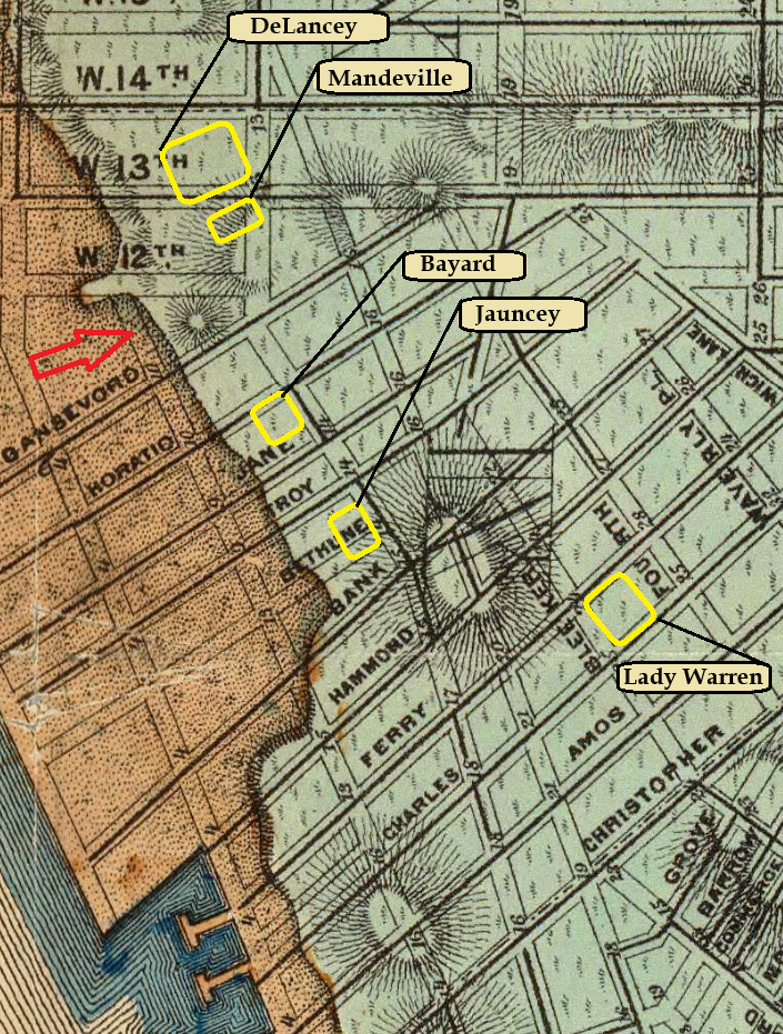
Detail of Viele Map, 1865, showing Greenwich Village, with author annotation.
The Viele Map is a great accompaniment to Janvier’s description of Lady Warren’s home (above):
The house stood about three hundred yards from the river, on ground which fell way in a gentle slope toward the waterside. The main entrance was from the east; and at the rear–on the level of the drawing room and a dozen feet or so above the sloping hill-side–was a broad veranda commanding the view westward to the Jersey Highlands and southward down to the bay clear to the Staten Island hills. Thomas A. Janvier, In Old New York (1894), p. 107-108.
Below:
Otherwise mundane details from the life and times of Oliver Delancey, and a 1773 survey map, may shed some light on a lost Lenape history, and perhaps even root modern history solidly in a Lenape past! (Salient points are underlined and reiterated below.)
May 23, 1762: Oliver DeLancey gets official approval to build Gansevoort Street.


Stokes Iconography: Chronology: The English Period, May 26, 1762 (6:725)
Reiterated from above:
- The new road would “bind to the Southward of the said Mandavells Land.”
- Oliver DeLancy would “have Liberty in [Lady Warren’s] Behalf to Fence in and Inclose the old road Leading to the River as private property.”
- It was worth mentioning, “The New Intended Road is Good Level Land.”
May 28, 1763: Oliver DeLancey complains to his neighbor about a fence.
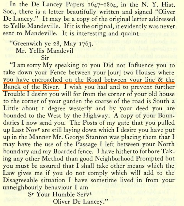
Stoke’s Iconography: Original Grants, and Farms: The Mandeville Homestead (6:119)
DeLancey “regrets” he couldn’t convince his neighbor, Mandeville, to “take down your fence between your [our] two Houses where you have encroached on the Road between your line & the Banck of the River.”
Below is the Gerard Bancker survey (1773) of the Peter Warren estate. The red star shows “the foot of Gansevoort Street,” where…
- The Sapokanikan trail began.
- A fence encroached on Oliver DeLancey’s access to the “Banck of the River.”
- Oliver DeLancey was given liberty to fence in and enclose an old road leading to the river as private property.
- The grid baseline began (though further out on landfill).
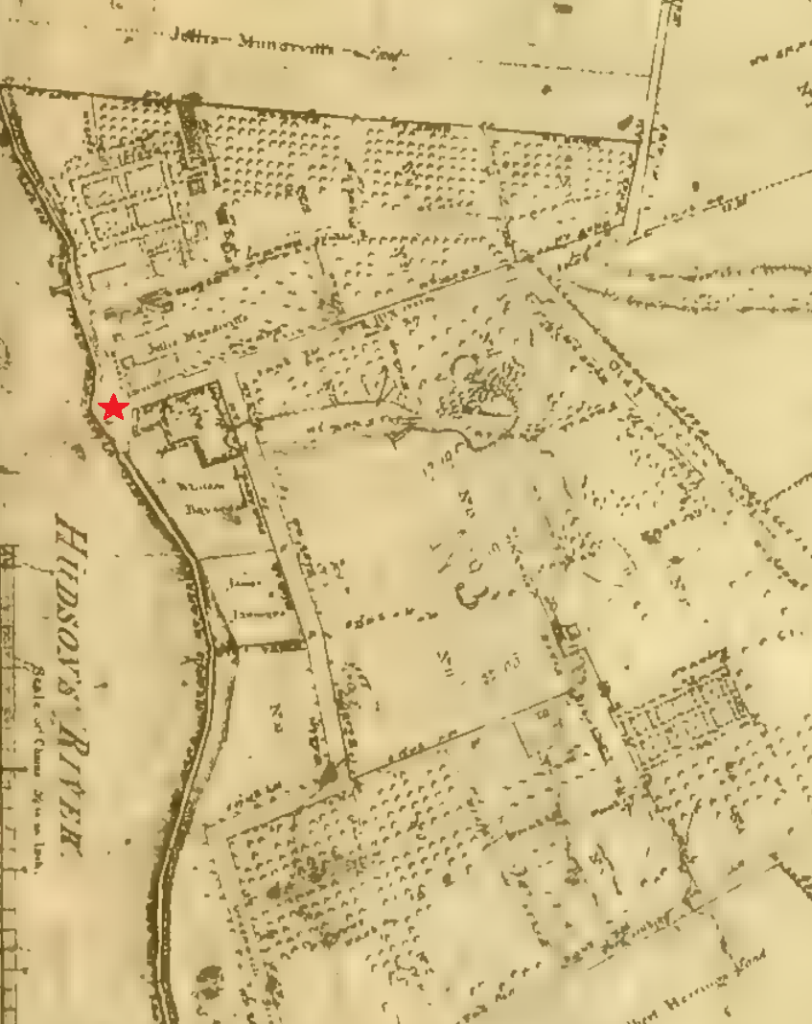
Gerard Bancker’s 1773 survey of the Peter Warren estate. Stokes, Iconography of Manhattan, Vol 3, Plate A. PL 5, with author annotation.
Highlighted from top to bottom: DeLancey, Mandeville, Gansevoort Street, Bayard and Jauncey.
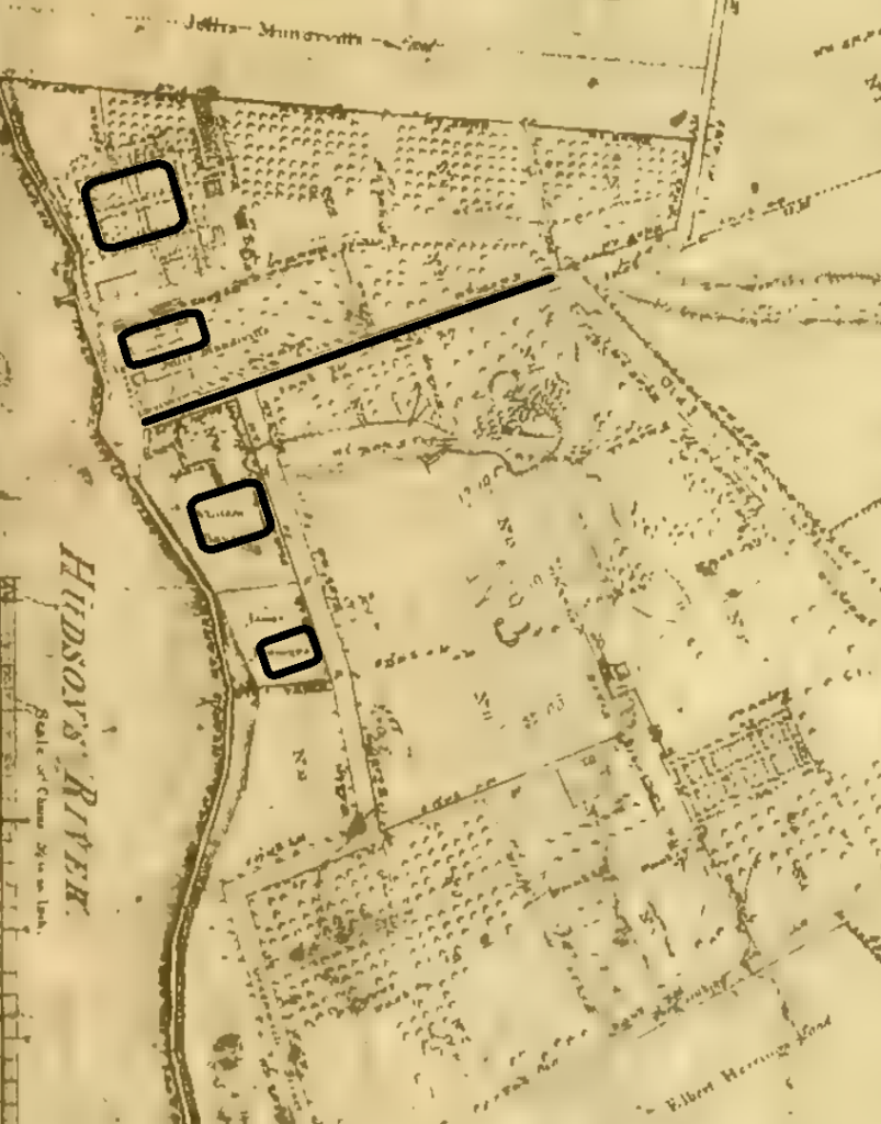
Detail of Bancker, 1773, showing Gansevoort Street, with author annotation.
The property line between DeLancey and Mandeville makes a clear connection between the start of the Sapokanikan trail and Greenwich Avenue! Remember that the Sapokanikan wagon road went “north of” Gansevoort Street. In a move to bypass Mandeville’s control of the waterfront access, DeLancey bypassed the circuitous Sapokanikan wagon road, and likely footpath. Here, too, did a footpath become a property line?
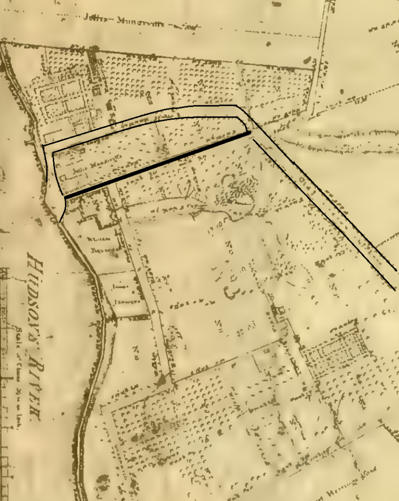
Detail of Bancker, 1773, with author annotation.
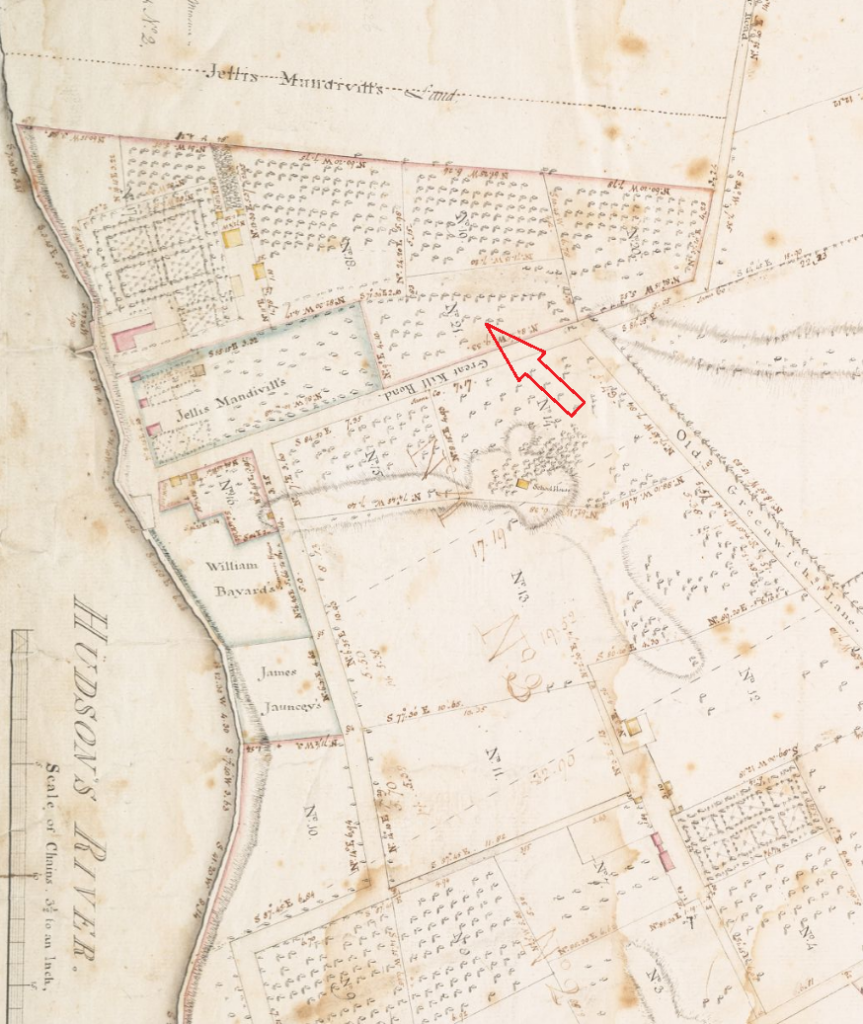
[row_inner_3] [col_inner_3 span__sm=”12″]Here is a more embellished, later version of the Bancker survey; the path can be seen more easily. The red arrow points to the location of the Mandeville family cemetery, at the other end of the estate. It seems, and what makes sense by the shape of the path, the families’ final resting place had a hillside for a backdrop, and the Sapokanikan trail, centuries older, went around it.
The Montresor Plan
The Montresor Plan (also done after the Stamp Act Riots of 1765) was made with an eye to military strategy, and emphasized elevations and defense. Note, too, we are at the periphery of the map.
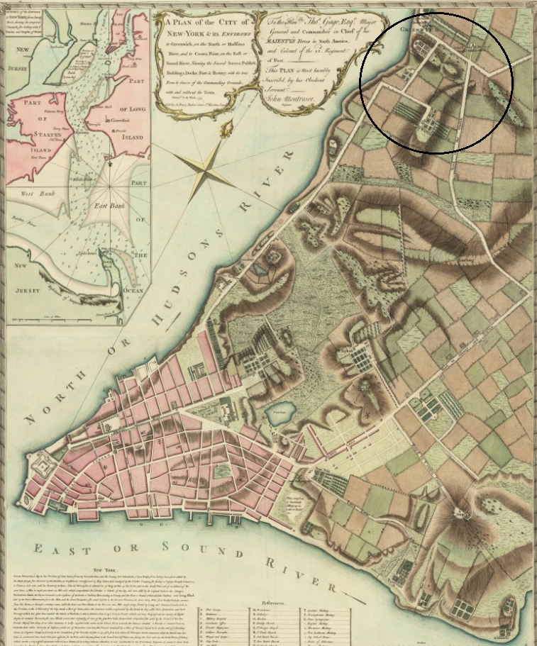
Plan of the City of New York (John Montresor, 1766). Image courtesy of Boston Rare Maps, with author annotation.
Below you can see the “three hills” mentioned earlier. It’s clear how the topography dictated the course of the footpath.
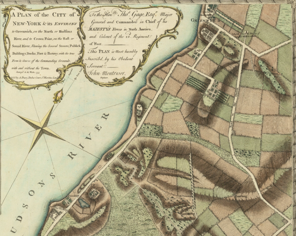
Detail of Montresor’s 1766 Plan, showing Greenwich Village.
Stokes noted the “Intended Road” (Gansevoort Street) was “Good And Level Land.” The new road may have further isolated Bayard’s hilltop home, hard against it.
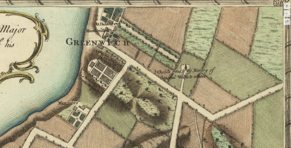
Detail of Montresor’s 1766 Plan, showing Gansevoort Street.
Below:
The orange arrow follows directly above the DeLancey-Mandeville property line. See the Wolfe Monument? A narrower path is “telescoping” out of Greenwich Avenue. What’s that about? Of course, unless someone was building a road to nowhere, that must be the Sapokanikan trail, and it intersects perfectly with the De-Lancey-Mandeville property line.

Detail of Montresor’s 1766 Plan, showing Wolfe Monument and Gansevoort Street, with author annotation.
The General Wolfe Monument was erected by General Robert Monckton who rented the Warren mansion between 1759-63. He planned a much longer stay and took an active role in shaping the landscape. Monckton served under General Wolfe, who died in the Siege of Quebec in the French and Indian War in 1759, the memorial was for him; it lasted only a few years, and no one knows what happened to it.
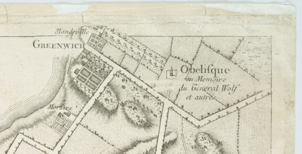
Detail of Montresor’s Plan, 1766, showing top right corner of map: Lionel Pincus and Princess Firyal Map Division, The New York Public Library. “Plan de New-York et des environs,” 1777. The New York Public Library Digital Collections.
The British Headquarters Map, 1782
Offically titled, B.F. Steven’s Facsimile of the Unpublished British Headquarters Coloured Manuscript Map of New York & Environs, 1782, and informally known as “The British Headquarters Map,” it is a stunning work from the Revolutionary War showing topography, roads, military and defensive infrastructure. (The next map is a close-up of Gansevoort Street)
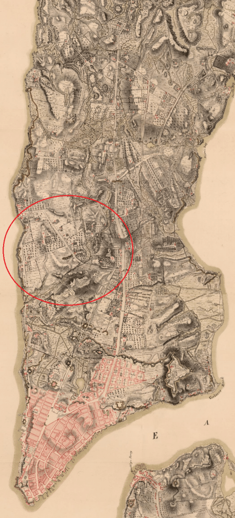
Great Britian War Office, 1782/1900; David Rumsey Map Collection, List No. 6403.000, with author annotation.
The British Headquarters map may show a few feet of the start of the Sapokanikan trail. One arrow points to the passage “at the foot of Gansevoort Street,” the other points to a shoreline road extending (maybe) 200-300 feet, ending just before the DeLancey-Mandeville property line. (And there’s no trace of the Wolfe Monument or the path to it.)

Detail of The British Headquarters map, 1782, showing Gansevoort Street, with author annotation.
The Kitchin Map, 1778
Done by a British mapmaker during the Revolutionary War, the Kitchin map may show two small sections of the Sapokanikan trail! The next map zooms in.
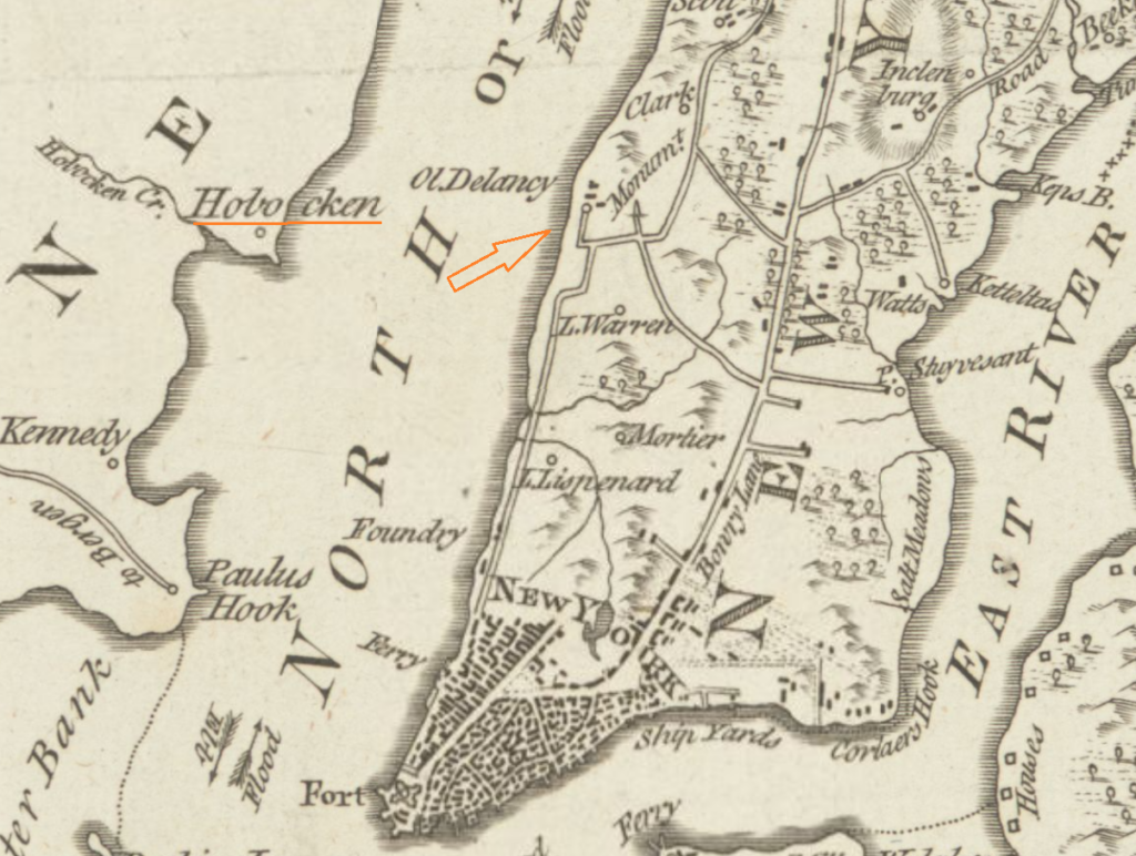
Kitchin, Thomas. Map of New York l. with adjacent Rocks and other remarkable Parts of Hell-gate. Map, London, R. Baldwin, 1778. Courtesy of Boston Rare Maps, with author annotation.
Do two arrows point to surviving “orphan spurs” of the trail that once connected around the hills above them (the third arrow)?
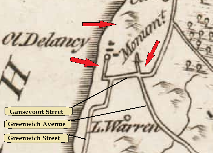
Kitchin Map, 1778, showing the Wolfe Monument, with author annotation.
Let’s look at the rest of the trail: the middle section (Greenwich Avenue), and the “zag” (Astor Place).
Sandhills were a major feature of the local topography, they were formed as glacial ridges. Stokes describes them:
The Sand Hills were a range extending from Richmond Hill in a semi-circular course toward the Bowery Road. In the Dutch vernacular, the locality was known as the ‘Zantberg,’ and is so named on some of the early maps. Along the westerly base of this range ran a brook called Minetta water, which took its rise at a point in the present Fifth Avenue, between Twenty-first and Twenty-second street, and ran a little east of that avenue as far as Eighteenth street, when it turned westward, crossed Washington Square, and emptied into the North River not far north of the old Richmond Hill. The road over the Zantberg was also sometimes called the ‘Obelisk road,’ sometimes the ‘Monument road‘, from the circumstance that it led past the obituary memorial erected in honor of General Wolfe, the hero of Quebec. (Stokes, 4:384)
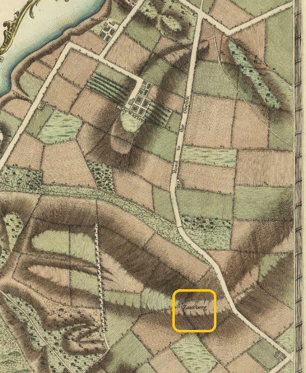
Detail of Montresor’s 1766 Plan of New York showing the Sand Hills, with author annotation.
Here’s the full path on the British Headquarter’s Map. (Note that Broadway did not go beyond the Sapokanikan trail.)
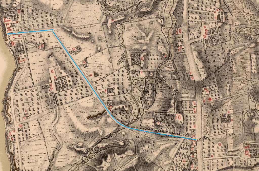
Detail of The British Headquarters Map, 1782, showing Greenwich Village, with author annotation.
Janvier describes a fashionable drive at the time:
For the greater convenience of the dwellers of Greenwich […] inland communication between that region and the city was provided for by opening a lane (formally approved in 1768) from the Post Road (now the Bowery) westward across the fields. Two sections of this lane still are in existence: the bit between the Bowery and Broadway (formerly Art Street) that is now Astor Place; and the bit between Eighth and Fourteenth streets that is now Greenwich Avenue. Being prolonged more or less on the lines thus established, the two sections met near the northwest corner of the present Washington Square.Thomas A. Janvier, In Old New York (1894), p. 118
[row_inner_4 v_align=”middle”] [col_inner_4 span=”6″ span__sm=”12″]Regulating and building “new” roads was often a case of widening existing roads. (Right) Stokes describes the earlier regulating and re-regulating of the road mentioned above. (Stokes, 4:459; Chronology: June 16,1707)
[/col_inner_4] [col_inner_4 span=”6″ span__sm=”12″]
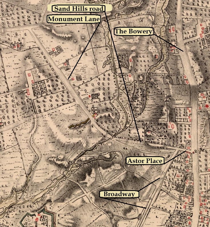
Detail of The British Headquarters map, 1782, showing Greenwich Village, with author annotation.
In her essay, Old Greenwich Elizabeth Bisland describes 125 years of Greenwich Avenue’s use as fashionable drive, from 1704 until 1823!
[row_inner_4] [col_inner_4 span=”6″ span__sm=”12″]
There’s good reason for leaving John Randel Jr’s work for the end. The two historic maps he produced were:
- 1807-1811, The Commissioner’s Plan, published as a single map, almost 9′ by 3′.
- 1818-1820, The Farm Maps (The City of New York as Laid out by the Commissioners), 92 maps in four volumes, 32″ x 20″.
Randel labeled what at the time should have been “Old Kill Road” (Gansevoort Street) differently, on both maps! There’s more, neither name was common other maps! Of course, he was documenting streets about to disappear, but it explains how the history could be so confusing.
The Commissioner’s Plan, 1811
Here, again, were Randel’s directives:
commence at the wharf of George Clinton, on Hudson River, thence running through Fitzroy-road [Gansevoort Street], Greenwich-lane [Greenwich Avenue], and Art-street [Astor Place], to the Bowery-road; thence down the Bowery-road, to North-street [Houston Street], thence through North-street in its present direction to the East River.
“Clinton” appears on the Commissioner’s Plan itself, referencing (it’s assumed) the “wharf of George Clinton.” The next map zooms in on where the baseline begins, “on the Hudson River, thence running through Fitz-roy Road.”
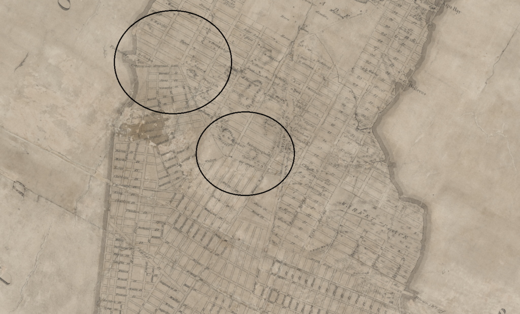
John Randel, Jr., A Map of the city of New York by the commissioners appointed by an act of the legislature passed April 3rd 1807 (aka The Commissioners’ Plan), 1811. Manuscripts and Archives Division, The New York Public Library, Astor, Lenox and Tilden Foundations, with author annotation.
See the four arrows below. Randel labeled Gansevoort Street (or Old Kill Road) as both “Fitzroy Road” and “Greenwich Lane.” Perhaps “Old Kill” was largely unknown, or the name was too common (or both). Given his directives to start at Fitzroy Road, perhaps he pragmatically put Fitzroy Road on the shore.
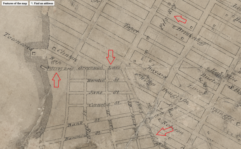
Detail the Commissioners’ Plan, 1811, showing the early labeling of Gansevoort Street in the West Village, with author annotation.
At the other end of the Sapokanikan trail, Greenwich Lane connected to Art Street along a path that went close to the northern end of Washington Square Park. That was the wagon road; it appears the footpath jogged north two blocks between sandhills.
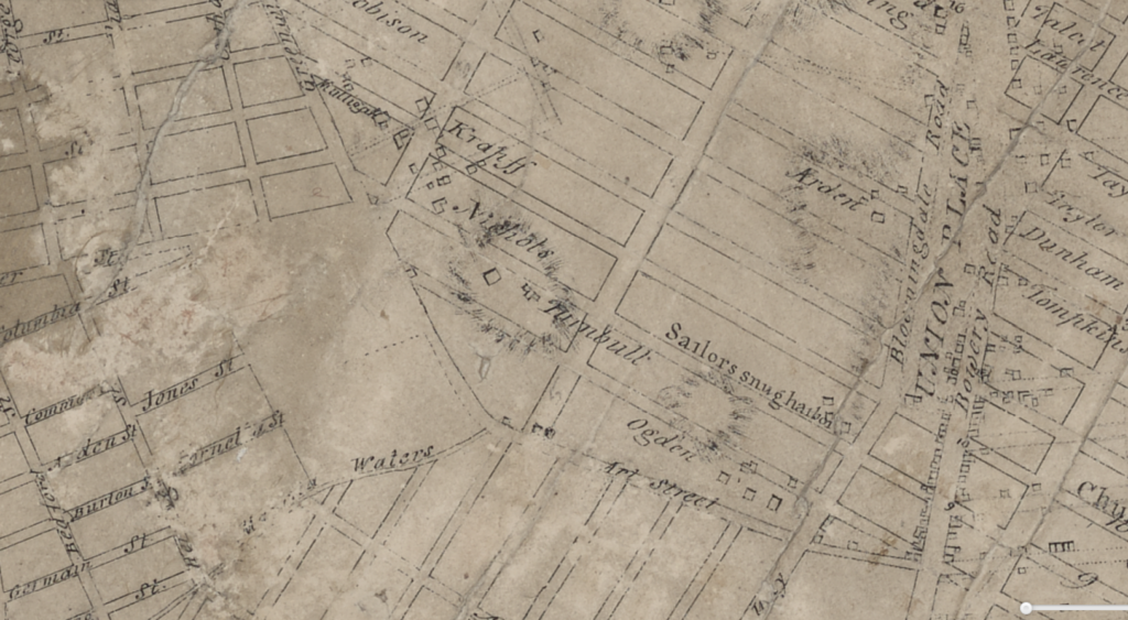
Detail the Commissioners’ Plan, 1811, showing the Sapokanikan wagon road and sand hills around Fifth Avenue and Washington Square, with author annotation.
If the footpath went through the sandhills, below is one such path the trail could have taken. (If you look back at the British Headquarters Map above, you can see the two paths, I noticed it after finishing the post).
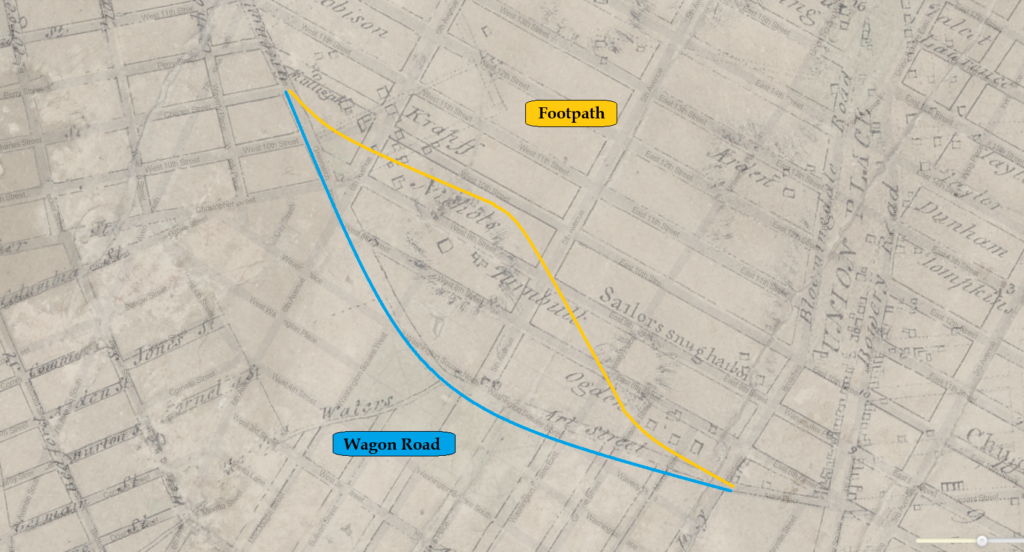
Detail the Commissioners’ Plan, 1811, showing grid plan with modern street overlay around Washington Square Park, with author annotation.
The Farm Maps, 1820
On Randel’s Farm Maps, Gansevoort Street is an extension of Greenwich Lane; Randel re-united the path!
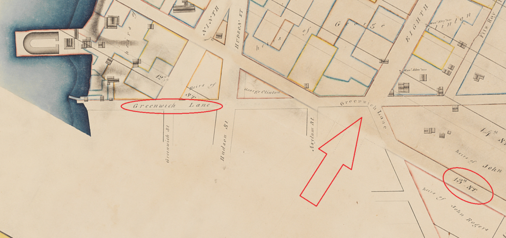
Randel Composite Map, online exhibit: The Greatest Grid: The Master Plan of Manhattan,1811 – 2011 (courtesy of The Museum of the City of New York). Map No. 4, vol. 3, p.1, showing Greenwich Lane to 13th Street, from Sixth Avenue to Ninth Avenue, July 23, 1819. Used with permission from the City of New York and the Office of the Manhattan Borough President, with author annotation.
The Greenwich Lane-Art Street connection is shown as the wagon road (in blue), and a possible route of the footpath between sand hills (in yellow); the Minetta River and Fifth Avenue are marked. The Washington Square Arch, at the beginning of Fifth Avenue, also marks the area of the river crossing of the Sapokanikan trail.

Randel Composite Map: No. 5, vol. 2, p. 1, showing Greenwich Lane to 13th Street, from Third Avenue to Sixth Avenue, December 1, 1819, with author annotation.
The Museum of the City of New York’s Randel Composite Map shows an extraordinary view of the grid baseline as the original S-shaped pattern of streets. While following the path of Greenwich Avenue makes sense, if the Commissioners weren’t following the Sapokanikan trail, why did they make the twists and turns at the ends?
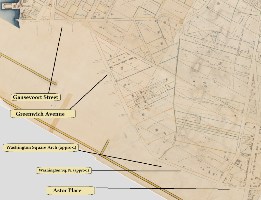
Randel Composite Map, online exhibit: The Greatest Grid: The Master Plan of Manhattan,1811 – 2011 (courtesy of The Museum of the City of New York), with author annotation.
At some point in the process, the conclusion can only be that Gansevoort Street, Greenwich Avenue and Astor Place would not exist if they didn’t follow the Sapokanikan trail, or a later itertaion of it. When seen together, three of Manhattan’s most incoherent streets make sense, but only when seen as the Sapokanikan trail.
Did the Commissioners know they were following the Sapokanikan trail? There’s remarkably little known about the process the Commissioners used to determine the grid plan, or indeed, if they even had a process. In City on a Grid: How New York Became New York, Gerard Koeppel lays out how a 1796 survey by Casimir Goerck (Below) was used as an embryonic blueprint for the Commissioners’ Plan, basically taking Goerck’s Fourth, Fifth and Sixth Avenues and extending them out. Goerck’s Plan also shows the Sapokanikan trail, though it wasn’t a boundary line!
Is it possible the Commissioners took what they wanted from Goerck’s Plan, and used “Goerck’s Sapokanikan trail” as the baseline and starting point for the grid? Just looking at Goerck’s Plan and where and how the streets of Greenwich Village (and the blocks below them) go off in different directions, maybe property values weren’t even considered.
In the opening of the post, the Museum of the City of New York exhibit stated, “the state legislature determined the grid would begin north of the population center.” If “population center” meant development and streets, then on the Goerck Plan at least, the Sapokanikan trail was the dividing line.
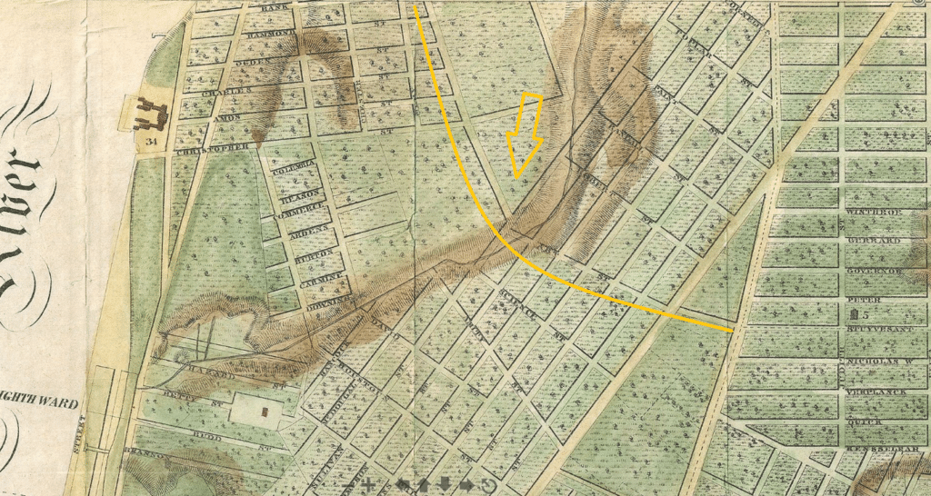
1801 Mangin-Goerck Plan of the City of New York (1856 re-issue). Drawn from Actual Survey by Casimir Th. Goerck and Joseph Fr. Mangin, City Surveyor. Mangin’s idealized plan of New York, courtesy of Geographicus Rare and Antique Maps, with author annotation.
The arrow above shows where Sullivan Street and Greenwich Avenue would have met at the river, inside Washigton Square Park.
It had been more than 150 years since the Dutch arrived, by then the trail had dissolved into a new world and landscape. The Commissioners may have been aware of the trail as much as an infant is aware of the bars of her crib. Then again, considering how little is known about the Commissioners’ decision-making, they could have been fully aware of the Sapokanikan trail; but they didn’t document anything, so why would they document that?
The land remembered though, and it made an impression on John Randel Jr.. Randel sought to impose a rational grid over the Manhattan landscape. What he wanted though, and what the Commissioners wanted, would be interrupted nevertheless by the ancient Lenape footpath. Those were the very words Randel used… interrupted nevertheless.
I’m including the full text (largely unreadable on its own), for context, it describes the path of monument markers along the grid boundary…the words you want to compare to all others are toward the end:
The northerly side of Eighth Street touches the southwestern corner of a house built on the northerly side of Stuyvesant Street, heretofore so called, and easterly side of the Bowery. The northerly side of Ninth Street touches the southerly side of Monument No. 9. The northerly side of Tenth Street touches the southerly side of Monument No. 10, and after crossing the Sixth Avenue becomes the southerly side of the same Tenth street. The northerly side of Eleventh Street touches the northerly side of Monument No. 11. The three last-mentioned monuments are placed near the easterly side of the Bowery road; and the Eighth, Ninth, Tenth, and Eleventh Streets extend westwardly to Greenwich Lane. The southerly side of Sixteenth Street touches the northerly side of Monument No. 16, placed near the western side of the Bloomingdale Road. The blocks between Eleventh and Sixteenth Streets are of equal breadth, and the Twelfth and Thirteenth Streets extend westward to Hudson’s River, being interrupted nevertheless by a northeasterly angle of Greenwich Lane. All the streets except First and Second Streets (which run into…
The Sapokanikan trail is recalled in a basic city fact: 14th Street is where the grid really begins as the first full crosstown street; and 14th Street has been a foundational social and cultural divide in city history. Because of three ancient hills in Lenape times, a footpath veered north a few hundred feet, almost to today’s 14th Street, before turning south to follow Greenwich Avenue. The “zig” in the Sapokanikan trail “interrupted nevertheless” a more full and complete grid, that, but for the Sapokanikan trail, might have begun at 12th or 13th Street.

Select bibliography
Berlin, Ira and Leslie M. Harris (eds.), in conjunction with the New York-Historic Society. Slavery in New York. The New Press, 2005.
diZegra Wall, Diana & Anne-Marie Cantwell. Touring Gotham’s Archaeological Past: 8 Self-Guided Walking Tours through New York City. Yale University Press, 2004.
Goodwin, Maud Wilder, et al. Historic New York: Being the First Series of the Half Moon Papers. G.P. Putnam’s Sons, 1898.
Homberger, Eric. The Historical Atlas of New York City. Henery Holt and Co., 1994.
Janvier, Thomas A. In Old New York, 1894. St. Martin’s Press, 2000.
Koeppel, Gerard. City on a Grid: How New York Became NewYork. DeCapo Press, 2015.
Monaghan, Frank & Marvin Lowenthal. This Was New York: The Nation’s Capital in 1789. Doubleday, Doran & Co., 1943.
Sanderson, Eric W.. Mannahatta: A Natural History of New York City. Abrams, 2009.
Stokes, I.N. Phelps. The Iconogrpahy of Manhattan Island, 1498 – 1909. Robert H. Dodd, 1915-1928.
Internet Resources (links to individiual maps embedded in post.)
Ballon, Hilary, curator and editor. “The Greatest Grid: the Master Plan of Manhattan, 1811 – 2011.” Online exhibition. Museum of the City of New York. Accessed August, 2026.
David Rumsey Map Collection. David Rumsey Map Center, Stanford Universtiy Libraries.
Geographicus Rare and Antique Maps.
Lionel Pincus and Princess Firyal Map Division. The NYPL digital collection, The New York Public Library.
The Miriam and Ira D. Wallach Division of Art, Prints and Photographs: Picture Collection, The New York Public Library. “The Ratzer map of New York City, 1767” The New York Public Library Digital Collections. 1877 – 1896.
[/col_inner_3] [/row_inner_3]