

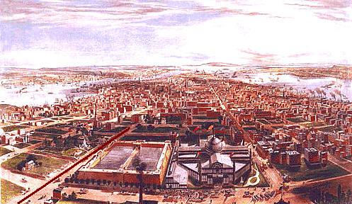
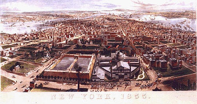
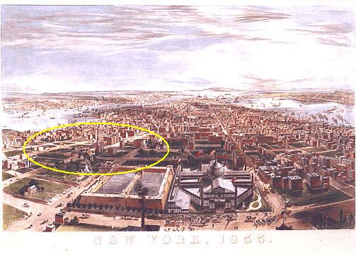
The last post showed the city from 63rd Street to the Battery by putting together two pictures from the 1850s. Here they are again; click here to read the original post. A painted line runs down Fifth Avenue in both pictures, and you can see the dome and flag of the Crystal Palace on 42nd Street in both. The top one is from 1855, the bottom from 1858.
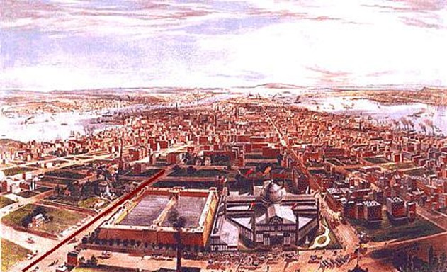
This post looks more closely at the first image. Most people know that the city grew from the bottom up, but what stands out is how much the city also appears to have grown from the outside-in. Many of the blocks in the center of the island have only a handful of structures.
There are a few notable geographic features visible in the picture. Murray Hill was a swath of land owned by a wealthy Quaker family during the Revolution. It’s where Mrs. Murray famously (perhaps apocryphally) delayed general Howe with her hospitality, allowing General Washington and the Continental Army to escape to the north of the island. As good Quakers, though, the Murrays did not take sides in the Revolution (and their economic interests, which were mainly shipping, straddled both sides). For their neutrality, many Quakers were expelled after the Revolution, and although they were permitted to return a short time later, many opted to remain in England.
You can detect the slope in the terrain of the actual hill extending from around 39th Street downtown past where the Empire State Building is today.
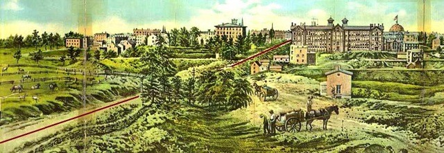
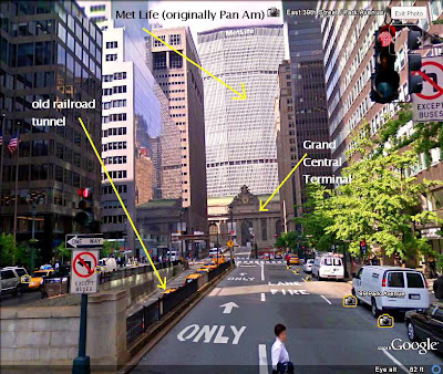
And you can see the Murray Hill railroad tunnel that today is an 8 block-long covered traffic tunnel running down the middle of Park Ave south of Grand Central. Below, the future tunnel appears as narrow empty blocks between the two sides of Park Avenue (then, 4th Avenue) that straddled the sunken passage. Today Park Avenue has one of the widest medians of any of the avenues, the only indication above ground of the dozens of railroad tracks running below the avenue from Grand Central (to the left out of the scope of picture) up to 96th Street.
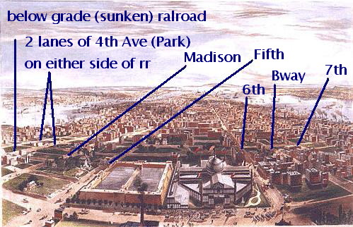
The passage was cut through Murray Hill so the horses wouldn’t struggle on the climb. After 1855 (the year of the picture), railcars were required to be horse drawn below 42nd Street so as not to be a nuisance to the growing residential population. Here’s the tunnel today. (I made these especially big and they overlap the side panels, but it’s worth it to see the pictures).
It’s also interesting to see what an ordinary road Broadway was in this part of town. Back in 1855 above 23rd Street it was the Bloomingdale Road, and would be renamed The Boulevard in 1866, finally taking the name Broadway in 1899.
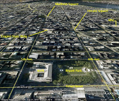
And there’s a good reason Madison Square and Herald Square do not appear to be significant parts of town…
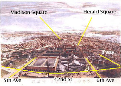
The center of town back in 1855 ran the stretch of Broadway from today’s NoHo and SoHo all the way to to City Hall. The town center would begin its shift to Madison Square around 1859, with the construction of the Fifth Avenue Hotel.
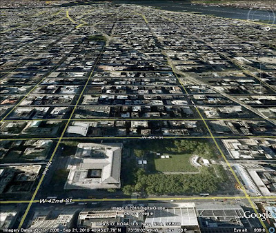
Here’s a rather dramatic view from the same perspective, using Google Earth. The NYPL and Bryant Park have replaced the reservoir and the Crystal Palace (though that structure only stood five years, 1853-1858).
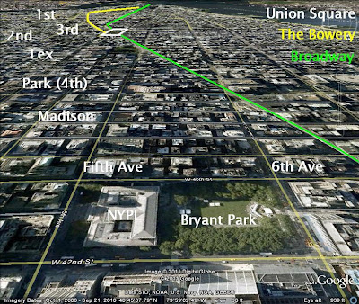
The commercial center of the city moved up Broadway, which from the tip of the island to within a few blocks of Union Square is uncharacteristically straight. The Bowery (in yellow) was the high ground, and the main route in and out of lower Manhattan though most of history. The city grew first up the Bowery before Broadway bridged Canal Street and the center of the city shifted over to Broadway around the 1830s.
I agree
Your Posts Very Interesting. In fact after reading, I had to go show it to my
friend and he ejoyed it as well! I have also some good Stuf check it.
splice ufx review
ufx review goodreads
get ufx review
ufx review global
ufx review deviantart
Thanks for sharing this excellent information. I really like this post.
getunderlined Instagram Photo Downloader
gapyear Instagram Photo Downloader
Instagram Photo Downloader poll
Instagram Photo Downloader shape
Instagram Photo Downloader bomb
I really loved reading your blog. I also found, your posts very interesting. In fact after reading,
Its really Great HelpFull Thanks
Linkdin
Amazing write-up!
Welcome to Primex Building Systems Pvt. Ltd
PEB Manufacturers in Delhi NCR
PEB companies
PEB companies in Faridabad
PEB Manufacturer
PEB Manufacturers in Faridabad
PEB Companies in Delhi NCR
Peb Structure Manufacturers
Peb Companies In Delhi
Thanks For sharing
curtain in Dubai
Nice article thanks for saring.
very informative and creative ideas love it.
Abu Dhabi Curtain
its really complex and detail explanation. great thinking and writing. useful and informative article. worth spend time reading this. Thanks
These are very Useful and Informative content! Thanks. Keep share this type of information.
Move 4 Less
Move 4 Less
Move 4 Less
Move 4 Less
Move 4 Less
Such a nice blog and i appreciate your all efforts about your thoughts. it’s really good work. well done.
Move 4 Less
Move 4 Less
Move 4 Less
Move 4 Less
Move 4 Less
Move 4 Less
Move 4 Less
Talking to women especially if I like them was always trouble for me. I can’t endure the thoughht I will get rejected. It will be blow to my self-esteem. For this reason, I prefer meeting and talking to girls online. Sofia Date helped me meet a sweet girl from Russia, Anastasiia, and we get along very well. russian dating
I am so grateful for your blog post. Really looking forward to read more.
Manhattan Boat Charters
Party Boat NYC
I got such a useful stuff on your website that helps me a lot to gain information.
BA 3rd year time table
thanks